Showing posts with label cocos corner. Show all posts

Sunday, February 11

Mojave Trail & Baja (Part 3)

After our successful rescue, we were back on the move and debated whether to head due east across the lake bed in hopes of intersecting the road which would take us south towards San Felipe.  It was a gamble taking the lake bed across to the east as we weren't sure exactly where it would bring us out, or if it even would.  We opted to backtrack the way we came in but this was now going to require us to go back through Mexicali to reach Mex 5 which would take us south again.  Our destination for the day was going to be Bahia de Los Angeles.  From there we'd get back on dirt and head south towards Pancho's place and San Franciscito.  I've been through this stretch several times.  It's always a fun experience stopping in and hanging out with a Baja icon, Pancho.  We planned to camp on the beach just down from his place and hang out for a few days. We ran out of daylight well before Bahia de Los Angeles and found an arroyo to drive up where we wouldn't be seen from the road.  One of my cardinal rules when in Baja is to not drive at night.  It's just not worth it considering the road conditions and the real chance of livestock or burros on the road.We camped in the arroyo for the night and broke camp early the following morning continuing down through Puerticitos, past CoCo's Place and then on to Bahia de Los Angeles, where one always has to stop for fish tacos.  I also ran into the store to pick up a bottle of Tequila and dog food for Pancho.  He lives about 40 miles from the nearest store so anytime someone brings some goodies he's very appreciative of it.  The remainder of the day was spent slogging along the rough ass dirt road south to Pancho's place.  We set up camp, hung out and did much of nothing for the next three days. A few fishermen and Pancho were the only others we saw and we had the beach to ourselves.  At night Pancho would come down for a beer or two and hang out by the fire with us.  With his limited English and our limited Spanish, we mostly sat around the fire, sipped on cold beer and listened to the coyotes back in the dunes.  One thing I was able to get out of Pancho was that the Tequila that I had just given him the previous day was.....finito!  Life in Baja!  More info about Pancho can be read here Pancho from an earlier post. 
View of Bahia de Los Angeles

Pancho
View from the beach looking towards Pancho's place.  He doesn't have much of a dwelling but oh the view and solitude.
Set up camp and stayed for three nights.
 Ike lounging around camp as the fishermen were heading out.
Launching early one morning.
Couple of fishermen came to camp one evening in search of water.  Their captain had left them for the night and forgot to leave any water.  Not that they needed to but they gave us this nice fish for some water and sodas.  I filleted it out and Wayne cooked it up for supper that night.
 A short hike over the beach dunes from camp and you could watch the sunset to the west.
An area of concern to me here was the boldness and quantity of Coyotes in the area.  Ike was constantly chasing them away from camp but I had to keep a close eye on Petey.  He could easily be snatched by a Coyote.  They were a constant around camp and would patrol the beach early each morning.
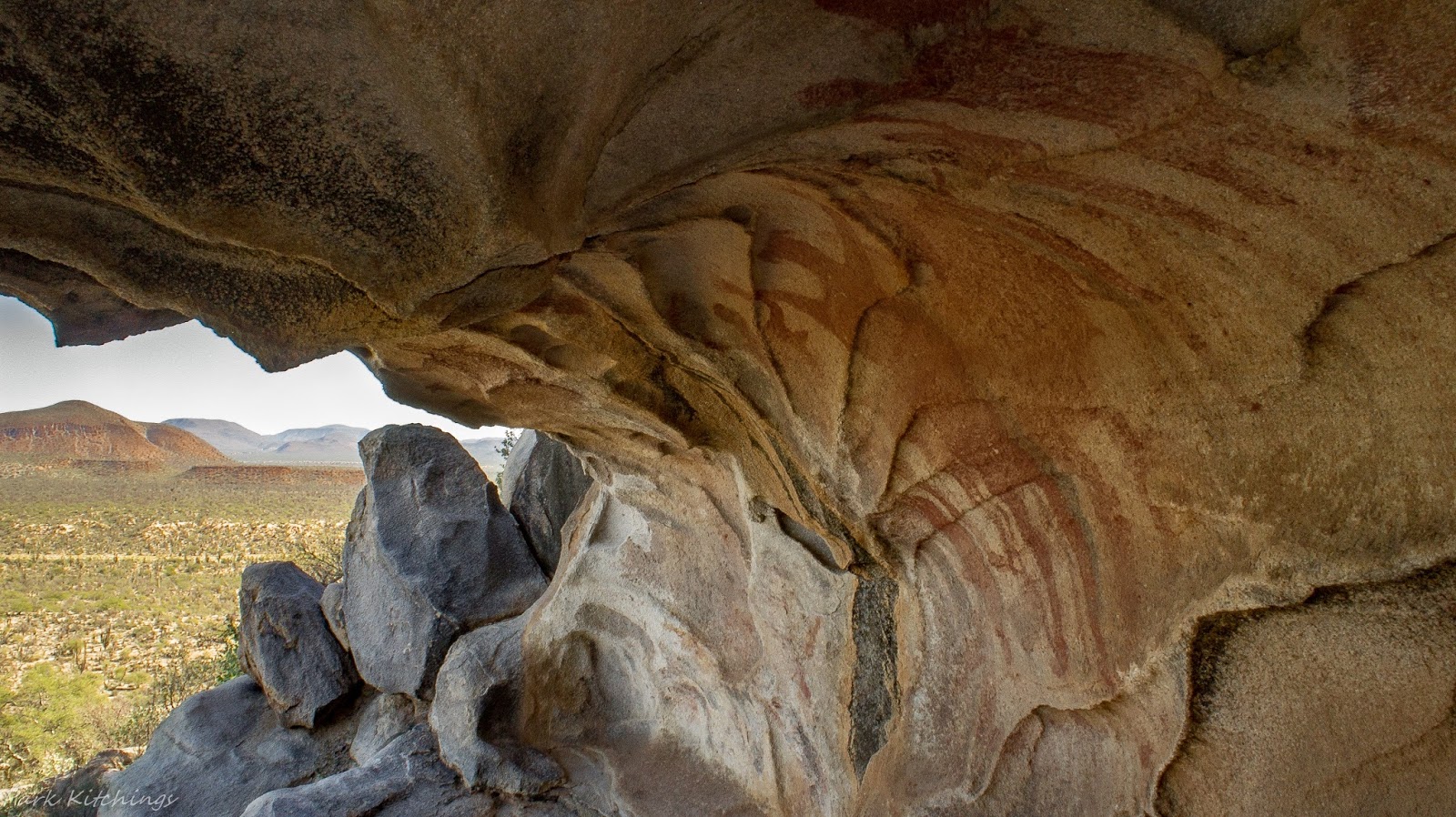
After three nights at Pancho's, we continued south where we spent one night at San Francisquito before turning west away from the Sea of Cortez.  The Baja 1000 race had just utilized this road the previous month and the trophy trucks had really done a number on it in places.  It was slow going until we reached San Francisquito. We had decided to cross back over to the Pacific side.  On the way, we viewed one of the most impressive caves with paintings I have ever come across.  I've seen many in Baja, but this one was special.  Interesting hanging out here and pondering what must have transpired here hundreds, if not thousands, of years ago.  A local we met in Francisquito told us about it.  It's not marked on any maps and if you don't know what dirt road to turn down it would be really tough to just stumble on it.  You park and have to hike in about a 1/2 mile with a little climbing and there it is.  The view looking out over the valley was impressive as well.  

Next, some new ground that Wayne, nor I, had yet been to in Baja.  

Friday, April 29

Final Post for Baja


There was one other area that I had been looking at on the map that I thought I'd check out before really putting the gas down to get back to the border.  The town of Guerrero Negro doesn't really offer much other than a spot to gas up and re-supply but I had been told of an old abandoned lighthouse which sounded interesting.  It's located at Puerto V. Caranza at the end of a spit which protrudes out in Laguna Gerrero Negro.  Since I was arriving in Guerrero late afternoon I decided to make the drive out and spend the night.  Pretty interesting place as it appears to be an old fish processing plant as well as the old lighthouse.  I even discovered some old graves that were in a strange place down between some decaying cement structures.  I'm assuming they placed the graves here since it was in the middle of the spit and the probability of flooding the graves was less. Pure speculation on my part but it was all I could come up with. Nothing that would indicate a cemetery, just some old grave sites randomly placed.  Looking across the laguna here you see miles and miles of some of the most beautiful sand dunes I've seen anywhere.  They are located on Isla Arena and it is inaccessible by vehicle, according to the maps.   If coming back here I think I'd see about trying to hire a boat to make the short crossing and spend some time exploring the dunes.  Looking at the shoreline with binoculars it appears there is absolutely nothing out there other than the pristine dunes.

What appears to be old grave sites down between the structures.

Old fish processing station.

 Another view of the structures and lighthouse.


Lots of birdlife out on the spit.

Following morning, it was back through some military checkpoints and then north to the border with a mandatory stop at Coco's Corner. Speaking of military checkpoints, a friend of mine gave me a video that someone he knew had put together.  Thought I'd post it up here as it's pretty funny.  Checkpoints down here are fairly straight forward.  As long as you aren't hauling anything illegal and don't act like an idiot, it's just a matter of allowing them to look around & ask a few questions before they send you on your way. I even kinda enjoy them as most of the time the guys are pretty bored and it's fun interacting with them. They always seem to be more interested in Petey than anything else I've got. Click on the link below to view.


Coco's Corner is about to change over the next few years.  Currently, from south of Gonzaga Bay to Chapala is a rough dirt road.  Coco's Corner sits about half way on this 30-mile route and has been a local landmark for many years with historical ties to the Baja 1000. Coco himself is a legend amongst racers, bikers and visitors to the Baja peninsula. A unique stop with a unique proprietor on this dusty, rough ass dirt road it has been visited by countless travelers over the years.  I fear this is all about to change as the new highway is under construction with the new route bypassing Coco's place. I was surprised at the amount of work that had been completed on it just in the past year since I'd been down.  Coco, who is in his 80's, told me that he doesn't want to live long enough to see the highway completed. There won't be another character like Coco once he's gone. It just won't be the same accessing Coco's Corner via a major highway.  Although change is slow in coming in Baja, it is inevitable. 

Clip from YouTube of Coco.  

A picture of Coco from last years trip.

After visiting Coco, I ended up bumping along the preferred "dirt road" before breaking out on the pavement near Gonzaga Bay where I camped for the night.  Following day, I made the crossing back over into the states at Mexicali. From there it was one more night of camping out in the desert on the US side where I needed to retrieve my buried pistol. I travel with a pistol while in the states (no...I'm not an armed nut job) and of course didn't take it into Mexico as that will land you in big trouble, real quick. I simply wrap the pistol in an oiled cloth, double bag it in gallon zip lock bags, mark the spot with GPS coordinates and bury it.  Thousands of desert acres to choose from so it's not a problem finding a remote site. Gun shops in the area want to charge you for storing it and since it's not some expensive piece, I just go the cheaper route and bury it. Plus I can retrieve it whenever I cross back over and not have to wait on someone to be open. As long as no one sees you digging your hole it should be there when you get back.  


 Final Baja moon as viewed from camp at Gonzaga Bay.  Was a great ten weeks in Baja and as I watched this moon come up over the hills I could only hope I'd be back one day.

Joshua Tree and Death Valley National Parks next.....