Sunday, October 8

Bella Coola.....Again (Part 2 of 2)

View was so good here we just pulled over at a wide spot in the road and stayed the night.

After a couple of nights back in the Odegard Falls and Purgatory Glacier area and worked our way back out to pavement near the little community of Hagensborg.  It's a bump in the road with a small grocery story, a one pump gas station and a couple of commercial campgrounds.  From there we  headed further west towards the Burke Channel and the actual town of Bella Coola.  Bella Coola lies at the end of the paved road and any further travel west from here requires a boat or plane.  It's certainly larger than Hagensborg but not by much.  The entire Bella Coola Valley, which is 50 miles in length, only contains approximately 2300 people. There is a forest service road out of Bella Coola that heads south and goes up over the pass towards the South Bentinck Arm and that was where we were headed. The road coming in here is pretty steep in places along with some washed out sections.  A four wheel drive is highly recommended on the road.  Possibility of fallen trees across the road can be an issue in here as well. It's about 14 miles in before the road surrenders to the brush and mud.  An old ATV trail continues on but the truck, four-wheel drive or not, wasn't going.   At the roads end you'll find a few spots to camp right along a beautiful mountain lake and a primitive hiking trail leading down to the Bentinck Arm.  I only hiked in a couple of miles before heading back to camp. It's a long way down, about 6 miles one way, and a steep grade coming back out.  Due to the mileage, muddy terrain and climb coming back it makes for a full day.  Too far for Petey and I'm nervous about leaving him for an extended period.   I always have visions that someone is going to break into the truck one day and steal him or the weather will turn warm and he'll overheat or something.  Not sure who in the hell would break into the truck as I saw one other vehicle camping  in here for 3 nights and the temps fell to freezing overnite.  What can I say, I'm a little over-protective or maybe I was using that as an excuse not to hike all day.

 Still some snow once you get up out of the valley.

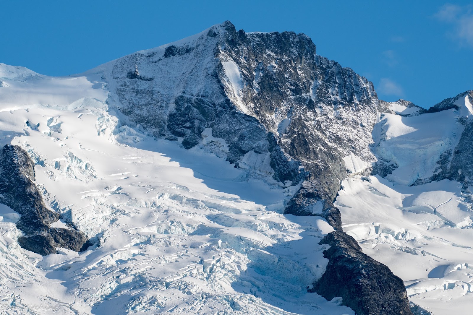
 Large glacier across the valley.

 The meadows up here were covered in blueberries.  After two days of hiking around I wasn't sure I'd ever get rid of the blue tongue and lips.  I ate enough of these damn things to bring down a horse.

 Blueberries attracted this guy as well.   You'd think he would want to be down in the valley feeding on the salmon but I think they really want to avoid any contact with Grizzlies.  He was fat and healthy though, so not sure he needed the salmon.


Got an invite one morning from a camp a few hundred yards from mine.  These were the only other people I say in here over three days.  Their family owned a ranch in Wyoming and cooked up some of their farm eggs, homemade sausage and hot coffee.  With frost on the ground that morning we  stood by the fire, shot the shit waiting for the sun, and wolfed down breakfast.

Petey and I spent the following night near this lake up on the pass.  I saw the big black bear pictured above just on the other side of this lake.  Having not had a good shower in over a week I did a little skinny dipping here one afternoon and I can tell you.....this water is cold!  Petey was watching me like I'd lost my mind.

Another black bear the following day on a hike near camp.

It's a beautiful area up here.  The view around every corner is stunning.

After a couple of nights in here it was back to Bella Coola where I decided to head east up out of the valley and do some exploring up on the Chilcotin Plateau.  I spent the afternoon at the harbor trying to get a ride across the inlet to an old fish cannery but couldn't score a boat ride.  Well, I did have a fellow say he could take me across but wouldn't be able to wait or come back for me so that wasn't going to work.  It'd be a long cold swim back to the truck.  I'd been told it was a really cool area with lots of photo ops.  Maybe next time.

Harbor at Bella Coola.  Cannery is on the other side of this inlet.

Here's something you don't see everyday.  A bull moose hanging out with cows.  A local had told me about this and where I might see it so I kept my eyes peeled and sure enough, there he stood.  Story is that he comes down in the valley from up on the plateau every year and to their knowledge is the only moose in the valley.  They guess he gets lonely and just likes hanging out with cows.  He's not a pet but a wild moose.  Not sure about the validity of this story but it's something I haven't seen before.

I spent one more night along the Atnarko River and you guessed it.....more Grizzlies.  If you haven't guessed it by now I enjoy watching and photographing bears in their natural habitat.  They are a majestic animal and should be protected.  They are currently being hunted as trophies in Canada by so called "sport hunters" and may lose their endangered species status here in the states.  It should be a criminal act to shoot one of these animals for mere sport.  I encourage you to visit http://www.davidsuzuki.org/issues/wildlife-habitat/projects/grizzly-bears/ to see what actions you might take to help save the Grizzlies. 

As I was standing along the river at daybreak on my last morning in the valley this beautiful Grizzly stepped out of the brush and struck this pose as the fog rolled down the river.  

 Sow and her cub at another spot later that morning.

Last one before climbing up over the pass to the Chilcotin Plateau.

We were headed towards Chilko Lake and then the Fraser River. The plan was to stay off-road and work my way towards Lillooet, camping for a few nights along the Fraser River.  Chilko Lake turned out to be kind of a bust as the weather turned and we got some cold temps and snow.  The lake is over 40 miles in length and one of BC's largest lakes above 3000 ft in elevation.  It's a vast area and a small portion of it is accessible via dirt road.  Floatplane, boat or hiking is the only way to really access and explore. I'd planned to stay at Chilko Lake a few days but after having to repair a flat in the cold and snow the following morning, and a dismal forecast for the next few days, I decided to keep working east.  Plus, I only saw one sow and her three cubs but couldn't get any pictures worth keeping.  Supposedly, the fires, along with a below average salmon run, had really affected the number of grizzlies that were coming to the area to feed. Grizzlies or not, the area has a lot to offer.  Over the next week we worked our our way back to Lillooet and then over to Gold Bridge and Pemberton before popping back out on pavement.  From there it was slab all the way down through Whistler, Vancouver and back into Tacoma.  

 Sheep along a ridge.

 Pair of bald eagles along the Fraser River.

 Mare and her foal.

 Young fox near an old barn at Chilko Lake.

 Fall colors were coming in.

Big open country here.

 Plenty of waterfalls to be found.

 Great horned owl near camp one night.
Carpenter Lake in the South Chilcotin Range.

 Exploring another side road on the way into Chilko Lake.

So many roads to explore.

Always make a stop at this old cemetery just outside an Indian village.

Figured these two had died together in a car accident.  So young.  Not sure why I like roaming around old cemeteries but I always seem to stop when I come across one.  Walking through and wondering about the occupant's past life is interesting.

Camp for the night along the Fraser River.

Although a mighty hunter, Petey does enjoy a nice warm bed in the camper at night.  He is currently catching up on his rest and will hopefully be back out roaming around somewhere soon.  


Friday, October 6

Bella Coola.....Again. (Part 1 of 2)


My main reason for coming to the Bella Coola Valley..... Grizzlies.

I hesitated going north to Bella Coola this year due to the forest fires BC had been experiencing over the late summer months.  My final destination of Bella Coola was fire free but the one and only road leading there had been recently closed.  After monitoring the road conditions, it looked like it was going to be clear after the Labor Day weekend so the trip was on.  The plan was to spend a week in the Bella Coola Valley and another week or so in the South Chilcotin Range.  Every time I go the area, this being my fourth, I discover something new.  The area ranks right up there as one of my favorite areas to explore.  Last time up here I was in the old motorhome which didn't have four-wheel capability and this trip I fixed that by coming up with the Toyota and the Four Wheel Camper.  If you want to remote camp and explore backcountry areas a four-wheel drive is necessary.  I had come up on Hwy 97 out of Hope, BC and the plan was to get off the pavement in Clinton.  From Clinton or Lillooet, you can access dirt/gravel roads and cut across the South Chilcotin Range before popping back out on pavement west of Williams Lake.  After jumping off the pavement in Clinton I ran into a road block by a fire crew in the area.  It looked like I'd have to backtrack and get back on the pavement when at the last minute the guy in charge decided to let me go through if I promised not to camp in the area and continue through to Hanceville.  It's probably about 80 miles or so to get through. He stated I'd be going through some bad burn areas and they were just now opening it back up to thru travel.  I was amazed at the devastation in the area.  I encountered some homes that were destroyed but couldn't bring myself to stop and take pictures.  You'd see the occupants standing out front or trying to clean up and you'd really feel for them.  Just didn't feel right to stop, gawk and start snapping pictures.

A rancher told me the driver was badly injured when he went off the road here trying to escape the fire when it was sweeping through this valley.

 Road grader didn't make it out.


Only around bodies of water was anything saved.  The remainder of the forest in this area was consumed by the fire.  Quite a contrast when I'd come up on a lake or pond.  The green with black everywhere else. I drove this particular road for well over 10 miles and the scene never changed.

After working my way through the burn area I had to cross the Chilcotin River where I ran into an RMCP Officer who was parked on the bridge.  He wanted to know where I'd come from and how I got into the area.  I let him know one of the fire crew's let me through.  Apparently, there was some miscommunication as I shouldn't have been let through and he couldn't let me cross the bridge.  I certainly didn't want to backtrack over the 80 miles I'd just done. At this point, I was only a few miles from popping back out on pavement.  Rather than have me backtrack all the way back through the area he consented and let me cross the bridge where I accessed Hwy 20 at Hanceville, better known as Lee's Corner.  It's an old established rest stop consisting of a little store, restaurant and gas station.  It was completely destroyed by the fire.  They had a dozer leveling everything in sight when I came through.  

I pointed it west and after about 30 miles turned back off pavement looking for a camp.  Headed into a place called Farwell Canyon and located an old homestead along the Fraser River.  Beautiful spot to spend the night.  Petey and I hung out, walked the river and explored the old homestead.

 Camp for the night.  Fairly recent gravesite on the right of picture.  Not a bad place to spend eternity.


 Short climb above camp gave you a better view of the Fraser.

 Hoodoo's across the river from camp.

While out hiking that evening spotted these juvenile Big Horn Sheep checking me out.

  After a night along the Fraser I drove into Bella Coola the following day. There had been some small fires in the east end of the valley but nothing in comparison to what had occurred up on the Chilcotin Plateau.  The area containing the fire in the valley is remote and requires four wheel drive to access.  Normally, you can drive all the way up this particular four wheel drive road but they had closed off a portion of it due to fire danger.  I spent the first few days in the valley looking for bears before heading up in the backcountry.  The bear viewing this time of year is great due to the salmon run on the Atnarko River.  The grizzlies congregate on the river to fatten up for the winter.  With some patience you can usually find bears.

 Sow and her cub.

 I had driven up the old Tote four wheel drive road and hung out at an old homestead in the area.  I could hear these cubs bawling at each other before spotting them.  They were raising a ruckus down river and hoped they were headed my way.  Eventually they came around the corner and I got to watch them for about 20 minutes before they disappeared in the forest. This sow and her three cubs were a lot of fun to watch but never really got close enough for good pictures.  Additionally, the lighting was really bad.  It was a miserable ride back out of this area as Petey found a nice fresh pile of bear scat and decided he needed to roll in and cover 90 percent of his body.  I never realized just how bad bear shit smells until you have to sit next to a dog for 15 miles.  I dumped him in the river, which was freezing cold, but it didn't do much for the smell.  A cold bath with Eucalyptus soap when we got back to camp did the trick.  The damn truck smelled like bear shit for the next week.

 Couple of cubs keeping a wary eye on me.

 Sow fishing for salmon while the cubs keep pace.

Same sow and her cubs.

How people with money photograph bears.  The rest of us walk, sit and wait!  It's really a hit and miss proposition in seeing bears.  Biggest factor is having the patience to hang out all day in areas where they are known to feed along the river.  The surrounding forest is so thick in places you could be 10 feet from one and not know it. I've talked with people getting off a guided boat tour that didn't see anything all day wherein I'd seen several bears that same day.  The poor man method had also resulted in zero sightings where the money people had seen a bunch.  You just never know, it's mostly luck, but I would say that your chances of seeing bears are better via a drift down the river as you're able to cover a lot more ground.  Only problem.....$175 bucks per head for about a 3 hour float and that doesn't include lunch! I'll walk thank you.

After hanging out along the Atnarko River for a few days I decided to head up into the backcountry.    There are a few forest service roads leading up out of the valley.  They gain quite a bit of altitude and most require four wheel drive in places.  I had attempted to drive the old Chinook up one of these roads last year and couldn't make it.  This year, with the Toyota, I was headed in.  Your chances of sighting any grizzlies up this high are pretty minimal this time of the year but your chances of seeing black bears are good. The grizzlies come down when to feed and are congregated along the streams containing salmon. Black bears are more likely to be up higher in the meadows chowing down on blueberries.  Black bears and grizzlies are rarely seen feeding together.  I've watched black bears feeding on salmon before and as soon as a Grizzly shows up the black is gone.  A grizzly certainly won't do the same when a black bear shows up.  No doubt who is the boss in the bear world.

 About a 20 mile drive in will get you across a valley which holds the Purgatory Glacier.  The old forest road comes to end along a slope and this is your view.  An awesome place to spend the night.


 When travelling these backroads a little work may be required to get through in places.  Here, twenty minutes with an axe and a pull with the tow strap and I was on my way.

Sunset along the Bella Coola River running through the valley.

 Old forest service road into Odegard Falls.

Odegard Falls on the way into the Purgatory Glacier campsite.  These falls drop over 800 feet.

 Petey getting some hiking in near camp at the Purgatory Glacier site.


Headed back to pavement after a couple of nights in the backcountry.

(Part 1 of 2)