Showing posts with label baja. Show all posts

Saturday, February 17

Mojave Trail & Baja (Part 4)

Church in a small village outside Bahia Tortugas

We'd been on the Sea of Cortez side and were now working our way back across the peninsula to the Pacific side.  Wayne had some beta on the Peninsular De Vizcaino area of Baja that neither of us had been to and we wanted to check it out.  We had been out to Bahia Ascuncion a few years ago but were looking to access some new terrain further west.  It was reported to be remote with some challenging conditions.  We spent the remainder of the day working our way across to the Pacific side.  Rolling into Bahia Tortuga well after dark we opted to find a motel in the fishing village.  Our  $20 room wasn't much but it did have running water and the owner allowed us to park our rigs in the locked compound.  The owner didn't speak any English but we were able to get some information on the area we were headed to by showing him our maps and doing a lot of pointing.  We first wanted to drive all the way out to the point and the little fishing village of Punta Eugenia and Chester.  Here the gravel road ends and we had to backtrack back to Bahia Tortugas to access what we'd come for. The total off-road route once we left pavement would be around 90 miles, a mixture of really soft sand and some rocky sections.  Airing the tires down in the soft stuff was the only way to get through but we were worried about the grade in some places.  We pulled up to a couple of spots that I wasn't sure I could get up.  Wayne had already gone up one of the larger dunes and I got out and walked it.  The first couple of tries were a no go and I had to back down.  Eventually, with a speed run at the bottom section, I was able to top out.  Our main concern, once we crested out in the dunes, was the wash which we'd need to locate to get along the coast and also lead us back out to the pavement.  This is one of the main things I love about exploring Baja, you never know what's going to be around the next corner and what the conditions will be.  Where we were at there certainly aren't any road signs.  Route finding plays a key roll in places.  We continued working our way through the dunes and as dark was coming on I noted a steep side road leading down to the coast.   I got out and walked it all the way down to ensure we could get back up.  It was a great campsite along the coast and we had no problems coming out the following morning.  We debated staying two nights here but opted to move on.  Later that night as we were sitting around the fire we noted truck lights way off in the distance.  We found this a little strange as there is absolutely nothing out here for probably 30 miles in either direction.  It's pretty tough driving in places and the direction they were headed was even more remote.  I suppose they saw the fire once up on the higher dunes.  Anyway, they kept coming and eventually pulled into camp.  Always a little disconcerting when someone rolls into your camp well after dark.  We met them, two men in a pick-up, as they pulled down the sandy road into camp.  Due to the language barrier, we never really did ascertain what they were doing that far out in the middle of the night.  They eventually left after it appeared they were sizing up the Gringos.  We were probably reading a lot into the whole situation but it doesn't hurt to be a little cautious when this far out.  Once we realized they'd made the turn and were headed to our camp I slipped a can of bear spray in my back pocket.  Better safe than sorry.  Ike, Wayne's dog, is a pretty good deterrent when unexpected guests roll in.  There is no doubt he means business.   Plus, there's always Petey.  No one, and I mean no one, wants a piece of Petey!  
Fishing village.

Camp for the night.
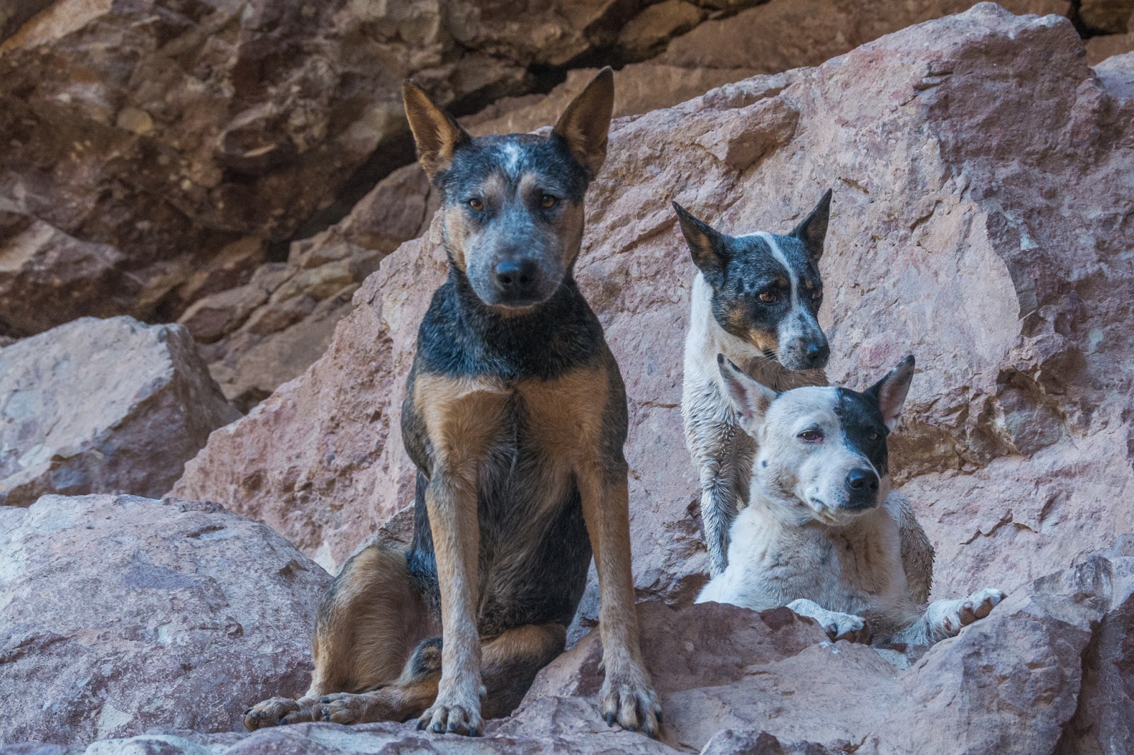
Petey hanging out in camp.  I ask you....would you want a piece of this?  I pity the fool that rolls into my camp uninvited!
Truth be known......Ike is what I wouldn't want a piece of!
Whale backbone that was washed up on the rocks below camp.
Found pockets along the coast where these large rocks had been tumbled smooth and round.
Following day we kept working our way through the dunes in search of the wash which would lead us to the coast.  Our plan was to access the coast and drive along the beach to access a point that was reported to have some excellent fishing.  Coming out of the dunes we eventually hit the wash but there was a problem.  Once we dropped down this dune there was no way we're going to go back up it.  It wasn't that tall but it was steep and the sand like sugar.  I had no doubt I couldn't come back up it once I dropped down.  Once in the wash, a left turn would take us 8 miles to the coast.  A right turn and 25 miles up the wash would get us back to the pavement.  If the wash closed out headed back out to pavement this could turn into a real adventure. We dropped in, turned left and were stymied about a quarter of a mile from the coast.  The wash was really rough in places and slow going over small boulders.  The wash kept closing down and eventually closed out leading into an estuary which was holding quite a bit of water.  We had to walk the remaining 1/4 mile to the beach.  No way we were getting the rigs in there as there were dunes on either side of the wash that we couldn't  get over.  We were pretty disappointed as the area was remote and the camping would have been excellent out on the beach.  Wayne had visions of catching some big fish in here as well.  The beach here is massive and runs for miles in either direction.  I forgot to take the camera down but we saw multiple whale bones and a perfectly good sea kayak that had washed up on the beach.  Anywhere else and that kayak would have found a new home but we had no way of hauling it out of there. This is one of those areas that you've got to work at to get to. I'm sure we would have stayed in here for multiple nights had we made it.  Hopefully, we'll be back to this area and with some changing conditions can access the beach next time.  
Pictures never seem to depict the steepness of something...it was steeper than it looks here.  Wayne named this Commitment Dune.  I was coming down it but was pretty sure I couldn't come back up it.  
After failing to make the coast we turned around and drove a few miles back up the wash and set up camp.  In this picture you can see the steepness of the dunes.  Not tall, but just steep coming up out of the wash.  Was a beautiful night in a remote area.  With a couple of cold beers and an excellent meal that Wayne cooked up, we sat around watching a meteor shower late into the evening.
We gained some high ground and Wayne was glassing for pavement.
 Spent the day crawling back out to pavement.


Petey was exhausted!
  

Sunday, February 11

Mojave Trail & Baja (Part 3)

After our successful rescue, we were back on the move and debated whether to head due east across the lake bed in hopes of intersecting the road which would take us south towards San Felipe.  It was a gamble taking the lake bed across to the east as we weren't sure exactly where it would bring us out, or if it even would.  We opted to backtrack the way we came in but this was now going to require us to go back through Mexicali to reach Mex 5 which would take us south again.  Our destination for the day was going to be Bahia de Los Angeles.  From there we'd get back on dirt and head south towards Pancho's place and San Franciscito.  I've been through this stretch several times.  It's always a fun experience stopping in and hanging out with a Baja icon, Pancho.  We planned to camp on the beach just down from his place and hang out for a few days. We ran out of daylight well before Bahia de Los Angeles and found an arroyo to drive up where we wouldn't be seen from the road.  One of my cardinal rules when in Baja is to not drive at night.  It's just not worth it considering the road conditions and the real chance of livestock or burros on the road.We camped in the arroyo for the night and broke camp early the following morning continuing down through Puerticitos, past CoCo's Place and then on to Bahia de Los Angeles, where one always has to stop for fish tacos.  I also ran into the store to pick up a bottle of Tequila and dog food for Pancho.  He lives about 40 miles from the nearest store so anytime someone brings some goodies he's very appreciative of it.  The remainder of the day was spent slogging along the rough ass dirt road south to Pancho's place.  We set up camp, hung out and did much of nothing for the next three days. A few fishermen and Pancho were the only others we saw and we had the beach to ourselves.  At night Pancho would come down for a beer or two and hang out by the fire with us.  With his limited English and our limited Spanish, we mostly sat around the fire, sipped on cold beer and listened to the coyotes back in the dunes.  One thing I was able to get out of Pancho was that the Tequila that I had just given him the previous day was.....finito!  Life in Baja!  More info about Pancho can be read here Pancho from an earlier post. 
View of Bahia de Los Angeles

Pancho
View from the beach looking towards Pancho's place.  He doesn't have much of a dwelling but oh the view and solitude.
Set up camp and stayed for three nights.
 Ike lounging around camp as the fishermen were heading out.
Launching early one morning.
Couple of fishermen came to camp one evening in search of water.  Their captain had left them for the night and forgot to leave any water.  Not that they needed to but they gave us this nice fish for some water and sodas.  I filleted it out and Wayne cooked it up for supper that night.
 A short hike over the beach dunes from camp and you could watch the sunset to the west.
An area of concern to me here was the boldness and quantity of Coyotes in the area.  Ike was constantly chasing them away from camp but I had to keep a close eye on Petey.  He could easily be snatched by a Coyote.  They were a constant around camp and would patrol the beach early each morning.
After three nights at Pancho's, we continued south where we spent one night at San Francisquito before turning west away from the Sea of Cortez.  The Baja 1000 race had just utilized this road the previous month and the trophy trucks had really done a number on it in places.  It was slow going until we reached San Francisquito. We had decided to cross back over to the Pacific side.  On the way, we viewed one of the most impressive caves with paintings I have ever come across.  I've seen many in Baja, but this one was special.  Interesting hanging out here and pondering what must have transpired here hundreds, if not thousands, of years ago.  A local we met in Francisquito told us about it.  It's not marked on any maps and if you don't know what dirt road to turn down it would be really tough to just stumble on it.  You park and have to hike in about a 1/2 mile with a little climbing and there it is.  The view looking out over the valley was impressive as well.  

Next, some new ground that Wayne, nor I, had yet been to in Baja.  

Thursday, February 8

Mojave Trail & Baja (Part 1)

Plan was to head back down to Baja for about two months.  Tiffany and the boys would fly down during the Christmas holidays.  I made a call to my friend, Wayne, up in Canada as I knew he was headed down as well.  We decided we'd meet up before crossing the border, jump on the Mojave Trail for a few days, and then cross the border together.
I arrived a couple of nights before Wayne where I camped, hiked a little and explored the area for a couple of days prior to his arrival.  Wayne arrived late one afternoon and we departed the following morning to get on the trail and head east.  Our first order of business was a fairly substantial water crossing. I was first in line and when I pulled up to this my thought was that I should get out and walk across to check for depth and bottom conditions, or possibly end up swimming, the crossing to ensure it was a doable crossing.  I opted for the "go big or go home" method and threw caution out the window, slowly pulling in.  This crossing is probably well over 100 feet in width and as the water started creeping towards the bottom of the window I began praying that it didn't get any deeper and god forbid, the engine stalls out.  With the water level approaching the bottom of the window I thought I'd made a big mistake but after a few tense moments the truck eventually started crawling out the other side.  Exiting the truck, water poured out of the cab.  Carpet was wet but hey, I'm in the desert and it will dry.  I grabbed the camera and shot Wayne coming across behind me.  This was certainly the deepest crossing I'd done with my Tacoma.

The remainder of the day we crawled east along the trail where we became lost a few times.  Tough following the trail in places as it exits out of some major washes and you just don't know which direction to take.  We ended up in some large dunes where we became stuck but eventually reconnected with what we assumed was the trail. We were still lost but enjoyed a spectacular full moon and ended up making camp for the night.

 The trail is out there somewhere.

Stuck!
 
  Moon rising as we looked for a campsite that evening.


The following day we got back on the trail and kept working our way east towards Marl Spring.  After camping at the springs the second night we needed to make a decision as to whether to finish the trail or cut off and head south towards the border.  The weather was really turning cold and it was forecasted that the winds the following day would be a consistent 40+ mph.  We decided that the warmer weather of Baja was looking good so after two nights on the Mojave Trail, we cut off and pointed the rigs south towards Baja.  I'll have to return later to finish the second half.

Camp at Marl Spring.


Stopped and did some hiking in the eastern part of the preserve.

Monday, June 6

Gear Review

Wherever the sun was shining you'd find the Overland Solar panel and Petey.  

First, I was not given this solar panel and paid for it just like anyone else.  If I didn't like the product I wouldn't be doing the write-up or listing a link on my blogsite.  I was asked to use the product and to write the review, good or bad.  I decided that if I didn't like the product I wouldn't be endorsing it.  However, I will receive a small stipend should you purchase anything by using the link on my blog.  So, if you purchase please use my link!  It will help keep me out on the road.  Just wanted to be upfront on all that.   Since I'm writing I guess you've now figured out that I approved....with one exception.  Prior to heading down to Baja back in December, I decided to purchase a solar system to keep the camper battery charged during extended stays in one spot. On previous trips, I'd only been running lights in the camper and occasionally charging computer and camera batteries and could go days without needing to run the truck for re-charging the camper battery. Adding an ARB fridge/freezer to the system and my plans for being in one spot for longer periods was going to require some additional power so I started some research on solar systems.   My system has two batteries.  One for the truck engine and one for the camper.  A separator keeps any devices in the camper from drawing on the engine battery.  You don't want to be in some remote location and discover that you've drawn down your engine battery from running too much stuff in the camper.    It is unbelievable how much detailed information one can find on a simple solar system set up! Wattage, amps/hrs, load, cable gauge, controllers, battery types, etc., etc.!  One can spend days and drive yourself crazy trying to figure it all out. I simply wanted to ensure I had a large enough system to charge the damn battery so lights would work and my beer would stay cold.  I've been told when purchasing a solar system you can never buy too much but I wanted something that would hold up to some abuse, fold down to a storable size and again, keep the beer cold. My research showed that a 60-watt system would probably do the job but I wasn't sure this would be enough and remember "you can never have too much solar wattage".  Additionally, I did not want a system that had to be permanently mounted to the camper as I wanted to be able to move the panel throughout the day to maximize the solar input.  If parking in the shade you really limit the panels ability. Numerous others had recommended Overland Solar to me and I had looked at their product while at Overland Expo the previous year so I decided to give them a call.   I was in Tacoma at the time and when I called, the owner, Brian Wurts, was visiting family and not far from me.  After he discussed in detail with me the in and outs of the solar world he agreed to meet with me the following day to take a look at my rig and make some recommendations on what I needed.  We met up at the agreed time and Brian was more than helpful in explaining what I needed and how to run the wiring and utilize the panels.  Based on his recommendation I ended up purchasing the 90-watt system and followed his instructions on the wiring procedures.  I had to make one additional phone call to Brian with a question and again, he was more than helpful.  I've now been using the product for the past 6 months and highly recommend it.  The only thing I have found that I would change is to increase the length of the power cord.  It's not quite long enough and a longer cord would help keep the unit in the sun when camped among trees or parked in the shade. Even in Baja, which is sunny 90 percent of the time, I needed to move the unit to the other side of the truck on occasion.   It was doable but a longer cord would have made the job much easier. An accessory extension cord is available but wouldn't be needed if they'd make the primary cord about 10-15 feet longer.  You can buy cheaper stuff out there but Brian's stuff is solid and does the job.  The beer was always cold and my battery stayed charged throughout the trip.  Even on cloudy days it kept the battery at a sufficient level to supply all my power needs and I went as long as a full week without cranking the truck to charge off the alternator.  Rather than list all the detailed specs on the panel here just go to his site at Overland Solar for the nitty gritty stuff and a video.   The product performed as promised and Brian's customer service is exceptional.  If you have any questions on the wiring install on the FWC or further questions on the product feel free to contact me.

Soaking up those last drops of energy till the very end.

Friday, April 29

Final Post for Baja


There was one other area that I had been looking at on the map that I thought I'd check out before really putting the gas down to get back to the border.  The town of Guerrero Negro doesn't really offer much other than a spot to gas up and re-supply but I had been told of an old abandoned lighthouse which sounded interesting.  It's located at Puerto V. Caranza at the end of a spit which protrudes out in Laguna Gerrero Negro.  Since I was arriving in Guerrero late afternoon I decided to make the drive out and spend the night.  Pretty interesting place as it appears to be an old fish processing plant as well as the old lighthouse.  I even discovered some old graves that were in a strange place down between some decaying cement structures.  I'm assuming they placed the graves here since it was in the middle of the spit and the probability of flooding the graves was less. Pure speculation on my part but it was all I could come up with. Nothing that would indicate a cemetery, just some old grave sites randomly placed.  Looking across the laguna here you see miles and miles of some of the most beautiful sand dunes I've seen anywhere.  They are located on Isla Arena and it is inaccessible by vehicle, according to the maps.   If coming back here I think I'd see about trying to hire a boat to make the short crossing and spend some time exploring the dunes.  Looking at the shoreline with binoculars it appears there is absolutely nothing out there other than the pristine dunes.

What appears to be old grave sites down between the structures.

Old fish processing station.

 Another view of the structures and lighthouse.


Lots of birdlife out on the spit.

Following morning, it was back through some military checkpoints and then north to the border with a mandatory stop at Coco's Corner. Speaking of military checkpoints, a friend of mine gave me a video that someone he knew had put together.  Thought I'd post it up here as it's pretty funny.  Checkpoints down here are fairly straight forward.  As long as you aren't hauling anything illegal and don't act like an idiot, it's just a matter of allowing them to look around & ask a few questions before they send you on your way. I even kinda enjoy them as most of the time the guys are pretty bored and it's fun interacting with them. They always seem to be more interested in Petey than anything else I've got. Click on the link below to view.


Coco's Corner is about to change over the next few years.  Currently, from south of Gonzaga Bay to Chapala is a rough dirt road.  Coco's Corner sits about half way on this 30-mile route and has been a local landmark for many years with historical ties to the Baja 1000. Coco himself is a legend amongst racers, bikers and visitors to the Baja peninsula. A unique stop with a unique proprietor on this dusty, rough ass dirt road it has been visited by countless travelers over the years.  I fear this is all about to change as the new highway is under construction with the new route bypassing Coco's place. I was surprised at the amount of work that had been completed on it just in the past year since I'd been down.  Coco, who is in his 80's, told me that he doesn't want to live long enough to see the highway completed. There won't be another character like Coco once he's gone. It just won't be the same accessing Coco's Corner via a major highway.  Although change is slow in coming in Baja, it is inevitable. 

Clip from YouTube of Coco.  

A picture of Coco from last years trip.

After visiting Coco, I ended up bumping along the preferred "dirt road" before breaking out on the pavement near Gonzaga Bay where I camped for the night.  Following day, I made the crossing back over into the states at Mexicali. From there it was one more night of camping out in the desert on the US side where I needed to retrieve my buried pistol. I travel with a pistol while in the states (no...I'm not an armed nut job) and of course didn't take it into Mexico as that will land you in big trouble, real quick. I simply wrap the pistol in an oiled cloth, double bag it in gallon zip lock bags, mark the spot with GPS coordinates and bury it.  Thousands of desert acres to choose from so it's not a problem finding a remote site. Gun shops in the area want to charge you for storing it and since it's not some expensive piece, I just go the cheaper route and bury it. Plus I can retrieve it whenever I cross back over and not have to wait on someone to be open. As long as no one sees you digging your hole it should be there when you get back.  


 Final Baja moon as viewed from camp at Gonzaga Bay.  Was a great ten weeks in Baja and as I watched this moon come up over the hills I could only hope I'd be back one day.

Joshua Tree and Death Valley National Parks next.....

Wednesday, April 20

Deeper into Baja - Part 13


Now being back on the road solo I figured I'd just keep working my way north and didn't really have any set plans.  I had considered going back through San Francisquito and up for another visit with Pancho south of Bahia de los Angeles. I had told Pancho I'd try and come back through his way when heading north to bring him some supplies.  He wanted a calendar, dog food and Tequila. Doesn't take much to keep Pancho and his friend happy!  To do this route again would require about 80 miles of off-road if I took the turn off to El Arco and then worked my way up to his place along the coast.  I ended up not doing it and kind of felt bad about it but I didn't make him any promises.  I just didn't feel like doing that shit road again to get to his place.  I opted instead to check out a little village up in the mountains called San Francisco de la Sierra. A few miles outside the village is the Cueva del Raton paintings.  I came upon this sign near the mouth of the cave area and was actually surprised to find it in English.  This place is pretty well off the beaten path and the last five miles getting into the village is rough.  After reading the sign I went in search of "the local representative" who could hook me up with a guide.


There isn't much here other than a church, some goat pens, few buildings and one small little store attached to someone's home. When you roll into the village you certainly don't see anything marked where the local representative would be hanging out awaiting your arrival.  I ran across one other gringo in the two days I was here. After roaming around I finally located someone who seemed to know what I was after and the negotiations began. After many attempts to understand each other I paid my $150 pesos and thought I understood to be back at the cave entrance tomorrow morning at 9 am.  I knew it was happening tomorrow but the exact time was still in question as well as the actual meeting place.  Holding up my 9 fingers, pointing in the direction of the cave and getting the "Si Senor" confirmed it.  I got back to the truck and decided to drive outside of the village a ways prior to setting up camp.  Had initially started to camp in a field next to the church but an aggressive dog altered those plans.  One thing you have to be a little vigilant of down here, especially with a dog the size of Petey, is aggressive strays.  Most of the strays are friendly but every once in awhile....a bad one can be encountered.  Petey wants to play with all of them and this particular one was not in the playing mood.  Luckily, no harm was done but I didn't want to constantly be wondering where he was at, so Petey and I loaded back up to find a more remote spot for the night.  This is a really beautiful area with big slot canyons and huge vast vistas.  I learned that you can also make arrangements for mule trips down into the remote canyons.  


Goat ranching is the only means of subsistence. In this terrain, there are no crops to be found.

Found a remote spot a few klicks from the village and had two visitors that night in camp.  Old guy comes along on foot out of the brush carrying wood which he gathers as cooking fuel.  He comes up and I finally figure out that he's trying to tell me that he would be my guide tomorrow. I guess the "local representative" let him know a gringo was in town and wanted to see the paintings.  How in the hell he knew where I was camped at, or if he just happened to stumble upon me, I don't know.  I'd gone quite a ways from the village to camp and he just shows up a few hours later.  He gathered some more wood near camp and then headed off down the road. 


I'd now met my guide but the next visitor in camp seemed to be a much more important figure in the village. He rode up into camp and after the obligatory "hola" was exchanged we just kind of stared at each other. He had zero English and I didn't have enough Spanish to do much of anything else. I pointed at the camera, got the head shake so I took the one picture.  After we stared at each other for awhile he simply rode off.  Probably mumbling to himself.....another dumb ass gringo! 


Another visitor to camp.

Petey and I greeted our final visitor to camp later that night.  A beautiful full moon.

Following morning, I broke camp and drove back down to the caves.  Nine o'clock rolls around...no guide. Nine thirty...no guide.  Ten....no guide. Petey and I walk around to kill some time but I'm figuring I've been stiffed.  Was worth coming in here regardless as it's a beautiful area but just as I'm getting ready to load up here comes the old guy I'd met in camp.  He unlocks the gate.  I look around and that's it. Their guiding consists of unlocking the gate and then taking a siesta on a big flat rock. Old guy had to be well into his 80's and had walked about a mile or so from the village to let me in. Friendly old fella who got tipped for walking that far and taking a siesta. I think they utilize the caves to generate a little income for the village which is only fair.


If into rock art and cave paintings Baja is covered in them. Access requires some off-roading and hiking but well worth it.  I find it interesting to explore some of these sites and wonder what their way of life was at the time. Another area that we'd been to earlier in the trip was up in the mountains east of Mulege.  I didn't post them up earlier but since I'm on the cave painting theme thought I'd throw them in here. If in the Mulege area it's worth the effort to get to these as well.


 Ranch hand that guides you back in the canyon to view the paintings.

 Of course, I liked his dogs.

Hiking back out of the canyon.

One more post in Baja before crossing back over the border........