Numerous times I've been asked to provide instructions on how to get to a certain place that I've been to, camped at or where exactly a picture was taken. I've even had some want to know if I would provide them with exact GPS coordinates so that their new-fangled machine can take them right to it. Depending on the wow factor of the area in question, they may or may not get directions but never GPS coordinates. One, because I rarely use my GPS anymore and two, I have discovered that half the fun is figuring out how to get to some of the good spots the old-fashioned way. Following a blinking line on a GPS just kind of takes the adventure out of it for me. There is something about breaking out your well-worn map, standing alongside your rig with your map on the hood, stabbing your finger at a spot and thinking to yourself....this is where I want to go. Directions in Baja are usually pretty vague depending on whether the information giver really wants you to find what you're looking for or not. Turn left at the second rusty culvert past where the goat, brown goat not the white one, is tied out to the old yellow painted fridge between kilo marker 40 and 50. You get the idea. This next area we visited is one of those places in my book. Is it some secret beach that very few gringos have ever camped at? God no, far from it..... but it is still one of those places not marked on the map with a big friggin "X marks the spot" or has a honking billboard out on the pavement with instructions to turn here. You either need to know exactly where the turn off from the pavement is or "go explore" and find it yourself. Now, some viewing this blog are going to instantly recognize the area once they view some pics. Others may want to know....where is that? Once you discover places like this you instantly become stingy and don't want anyone else to know about it. Of course, many already do, but you still feel that way to some degree. Like it belongs to you and a few other hardy adventurous souls. Of course, that's bullshit, but one can dream. When "X marks the spot" and the billboard is erected the charm will be gone. So until those things happen, I'm going to be selfish and keep my mouth shut. If you already know this area, you're lucky and I'm sure you hope to return one day to find it unchanged. Hopefully, you'll keep it to yourself or at a minimum.....give less than perfect directions if asked. Here are my detailed instructions to find this spot....it's at the end of a dusty ass dirt road in Baja. Good luck.
Some silt beds on the way in.
Drive in.
This is the last area Wayne and I camped prior to departing ways. I spent a week in this one spot and after I departed I think Wayne stayed at least another week before moving on.
This bay provides a great spot for sailboats to anchor up in. We had several different sailboats in the bay while we were there.
Petey and I out for a late paddle. (photo by Wayne)
Fish osprey and nest near camp. A hike up the ridge behind camp and I was looking down into the nest from the cliffs above. Would have been some great pics if the nest would have been holding some chicks but I think I was a couple of weeks early.
A lone wild burro near camp.
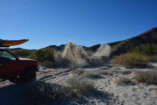
Wayne's rig is under that dirt spray. He was pulling someone out who was stuck on the beach.
The stuck party.
Speaking of parties. Our social event with the sailboat crowd. One of the skippers organized a "pot luck" and requested that we hold it our campsite.
The party crowd with their transports to the beach. Some of this crowd had some nice sailboats. Interesting, diverse group of sailors.
Petey and I visiting a former acquaintance I ran into on the beach the first day we arrived. Doug and Linda have been coming down to Baja for many years on their sailboat. I had known them through business dealings back in Bend and hadn't seen them for years. Was surprised to actually run into them down here. It's a small world.
Doug and Linda had us out for dinner and adult beverages one evening.
Doug & Linda aboard the "Que Linda".
Arno, another boater we met, invited Petey and I aboard while we were out paddle boarding one afternoon.
Petey returning to camp.
Drive back out to pavement and north towards the border. This poor fella hadn't been down long as the buzzards were just starting to circle. Pretty harsh environment in places down here.


Did you lose count? ¿dónde está el doce?
ReplyDeleteI have mixed feelings about revealing the location of special places. Thanks for the thoughtful explanation of your position on the topic.
Yep, screwed that one up. 12 - 13...... close enough but I went in and fixed it anyway. Sorry about that.
ReplyDelete