Showing posts with label alaska. Show all posts

Sunday, August 27

Alaska by Air - Tacoma by Sea

      Our ride south as we pull away from the dock in Anchorage.

I'm still not caught up on the blogposts from my five month trip touring the US but a quick trip up to Alaska in the meantime deserves a post.  After returning home in early August I had a couple of weeks of downtime before Tiffany and I were scheduled to fly to Alaska for a few days before boarding a cargo ship, M/V Northstar of Tote Lines, to get us back down to Tacoma.  Tiffany had won the trip last summer at a fund raising auction where the boys went to high school.    Tote donates passage to various charities but is not allowed to actually sell passage since they are a cargo vessel.  We were the only non-crew on the boat.  We boarded the boat in Anchorage on a Sunday around noon and arrived at the Port of Tacoma on Wednesday around 3 p.m.  It was a unique experience and one we were both glad we got the opportunity to do.  It's a no frills vessel, as it's a working ship, but we were provided a nice stateroom with a living area, attached separate bedroom, private crapper/shower and three square meals a day.   Had a TV with some DVD's, stocked fridge (sodas only as no alcohol is allowed on the ship) small library, games, etc.  The crew, which totaled 24 men, does nothing for you other than feed you, make sure you don't get in the way and provide a few tours of various sections of the boat.  You have access to the bridge, your stateroom, the galley and a couple of outside areas off the bridge.  Unless you're with one of the ships officer's that about covers it.  Ninety percent of the boat is set up to haul cargo so there's really no where to just roam around.  Very interesting as to how they load and unload the cargo.  It's what they call a RORO vessel.....Roll on, roll off.  All cargo is wheeled and the longshoremen can unload and load within 10 hours.  They dock according to the tide in Anchorage and only have the 10 hour window to get it done so the ship can get out on the next incoming tide. Cargo consists of semi trailers and vehicles.  Car/RV dealers and rental car companies transport their vehicles this way as well.   Pretty impressive watching them load the ship.  They're fast and they don't waste any space.  It's packed when they're done with it. The bridge is up top, our stateroom was one flight down and the galley right below that.  Not a whole lot of room to roam around in for almost four days.  I asked the Captain where in the hell the hot tub and pool were?  He stated they hadn't gotten around to installing those just yet. We're both glad we got to go but not sure I'd sign up again unless I had no other way to get back.  I've flown to Alaska, driven a truck to Alaska, motorcycled to Alaska, done the inland passage ferry from Alaska and taken a fancy cruise ship up once.  I'll opt for the drive, either truck or motorcycle any day over the other means. This was one of those experiences where once is probably enough.  I've heard of people going across the Pacific via cargo ship before.....trust me, that would be a long couple of weeks. 

Before boarding the ship we had a couple of days to kill in the Anchorage area so we booked an Air BnB in Anchorage for two nights and then one one night in Seward.  Friday was taken up with some hiking at the base of the Chugach Mountains along Lake Eklutna where we spotted two black bears and one sow grizzly with cubs.  All were at binocular range so.....no photos.

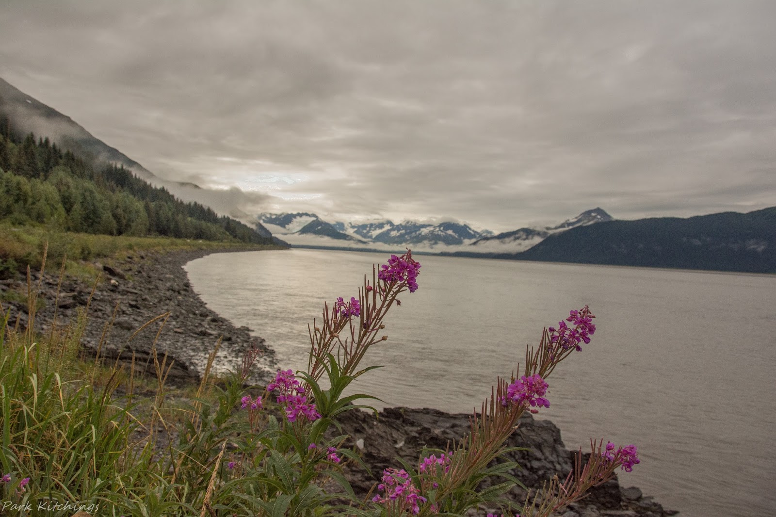
Lake Eklutna with the Chugach Range in the distance.

Break time.  We watched a black bear from here which was working his way along the shoreline on the other side of the lake.

Saturday we left Anchorage for the drive south on the Kenai Peninsula en-route to Seward with a stop at Bird Creek to watch some combat fishing.  I call it combat fishing because at times the fishermen are literally standing shoulder to shoulder.  I've done this and to be honest it's not a lot fun.  When you hook a fish it can get pretty hectic when it's really crowded. I've seen this place packed with fishermen before when the Salmon are really running.  I've also seen grizzly show up to fish.


I have hiked and camped out of Seward during some of my previous trips to Alaska and really wanted Tiffany to hike in and see the Harding Icefield if the weather would cooperate.  It's a strenous hike at about 10 miles roundtrip.  Distance is really nothing, it's the 3200 feet in elevation gain that first four miles that is the ass kicker.  Last time I hiked in here the weather was crap and you couldn't really see much of anything as I was in and out of the clouds.  This time, it was a perfect day for hiking.

Saw another black bear going in but as you can see, binoculars were in order again.  Would have been a good shot with the glacier in the background if I could have worked my way down to him and gotten close enough.  This is as close as we got and this was taken with a 600 MM lens.  Oh yea, black spot in grass on right side of picture in case you're asking.....what bear?  Told you we were a long way off.

 My hiking partner with the Exit Glacier in the background.

Exit Glacier coming off the Harding Icefield.

Tiffany likes to motor along when she hikes where I like to stop and doodle at every opportunity as evidenced by the distance between us in this picture.  As long as we were up high in the alpine zone I didn't mind her taking off but down lower in the thick stuff we stayed close as I was the one carrying the bear spray.  Since Tiffany had never done any hiking in Alaska I let her know that her normal head down, haul ass mode may end in her  becoming lunch for some surprised Grizzly.  She actually slowed down a little!


On the hike in observed these two on Exit Glacier.  Being there un-roped could end bad for someone.  I've done it, but it's not the smartest move I've ever made.

 Tiffany taking in the view.

Had to do the selfie thing overlooking the Harding Icefield.


Emergency shelter along the trail near the edge of the ice field.

After a great day of hiking we went back into Seward for a good meal, cold beer and a night in a motel that was 116 years old.  We don't think the place has seen much renovation in the past 116 years.  It was a cool spot with a lot of history but I was so tired I couldn't even think about the camera.  We ate and passed out.  Following morning we re-traced our drive and headed back into Anchorage to board the ship.


We were greeted by a representative of the ship and shown our stateroom.  From our windows we could watch the loading of the cargo.

First Engineer giving us a tour of the engine control room.

Cut out of the Northstar.  Ship was built in 2003 in San Diego for Tote Maritime and designed specifically for the run between Anchorage and Tacoma.

   Here we're standing on the stern of the ship with John, the Second Mate, who was a really nice guy.  He does six weeks on, twelve hours a day - seven days a week, and then has six weeks off wherein he starts it all over again.

 Tiffany headed down into the bowels of the ship.

 Anchor locker.

 On the upper deck this is the only way to get to the bow.  They leave just enough room along the side to walk.  They don't waste any space as they like to say......space is money on a ship.

Tiffany watching the pilot out of Anchorage leaving the dock.  We were told that we could come up on the bridge but were not to engage in conversation with any of the crew leaving port unless they engaged us first.  Well, the pilot pictured here did start talking with us and showing us what he was doing on the computer when the Captain cut that short.  He, the Captain,  took us off to the side and told us that when leaving the dock he wanted his crews full attention on their jobs as he had to get a 150 million dollar ship over some very shallow shoals.  The Captain later told me that that particular pilot loves to talk and he should have addressed it with him since we were on the bridge.  I thought maybe we were going to get booted off on the first day! He realized we didn't start the conversation and the pilot was at fault.  The ship has a pilot, who is not part of the crew, take the ship out of Port and the same happens when coming into Tacoma.  The pilots know the waters from years of doing it and comes on board specifically for that purpose.  Other than when leaving or entering port you could ask the crew or Captain anything and they were more than willing to show you what was going on.

The twin propeller shaft is over 145 ft in length.

Once leaving the Port of Anchorage you head out to open sea before turning south.  After about 6 or 7 hours you start losing sight of any land and are in open sea until arriving at the Strait of Juan De Fuca.  We had some bad weather the first couple of days with some rolling seas.  It wasn't real bad but you certainly knew you were on a ship.  The weather turned nice again as we entered the Strait so the camera came back out.

Pilot boat coming alongside near Port Angeles.

Pilot leaving the pilot boat and coming up the ladder.  A fall from here would be a long one.


 Seattle skyline.

 Port of Tacoma.

Tug coming alongside to get us lined up for the dock.

Trip complete.


Friday, December 18

Hell with this cold & rain!

Took Tiffany and the boys to the airport this morning.  They're headed off to Singapore, along with Tiffanys mother, for the holidays.  Having lived in the far east for a few years and really not into big cities with lots of people, I opted out. Instead, once I get the camper sorted/restocked and some truck maintenance done, I'll be heading south to meet up with some fellow overlanders prior to crossing the border the day after Xmas. Having gone solo on my trip down last year, I opted to alter my normal mode and hook up with a small group of like-minded travelers. Travelling solo in Baja, although not something I consider dangerous, was a little stressful at times.  Especially when off-road in some of the remote areas. Although I prefer solo travel, the added security afforded by travelling with others, will be welcomed. A major breakdown, injury or worse yet, an encounter with a few bad hombre's could certainly spoil one's day.  No question, Petey is a security guru, but he does have limits!     

I'm looking forward to another roam about south of the border. Once Baja is done with me, the plan is to work my east to Florida for a visit with family and maybe a detour to Key West. I should be on the road two months, maybe longer. Hopefully, some adventures, photo opportunities and interesting characters await while roaming about.  I also plan to do some gear reviews during the trip. The main one being a solar setup I recently purchased. The company owner, after seeing my blog, has requested a review once I've had a chance to use it. I also "plan" to provide a breakdown of trip expenses as I've received a few requests to do so.  Hopefully, I'll have the discipline to keep track of that stuff.  We'll see.

In the cold and rain tonite but that should change soon.  Some shots below from the trip last year. Stay tuned..........


Tuesday, October 27

Final push South

Bear Glacier on the drive into Stewart, B.C.
Rolling off the ferry in Skagway I sensed the end of the trip was near even though I still had over 1500 miles ahead of me.  I've been  guilty on past trips of picking up the pace on the final few days of a trip once the "turn around point is reached" and simply pounding out miles with a home destination the only goal. As I rolled off the ferry in a driving rain late that night I committed to continuing my established slow pace and enjoy the remaining days.  I headed about 10 miles outside of Skagway to Dyea, Alaska where I located a nice level spot around midnight and made the mad dash to pop up the camper in a torrential downpour. Skagway and Dyea are the major ports which supplied the Klondike Gold Rush. Located 600 miles south of the gold fields, towns were the closest salt water ports to the Klondike gold fields.  They became boom towns that catered to the miners.  Each was the trailhead for going over the mountain pass to the fields. From Skagway, stampeders took the White Pass and from Dyea they took the Chilkoot Pass. The rain continued throughout the night and my plans for hiking a portion of the Chilkoot Trail was not looking good.  No hiking occurred the following morning so I started east to intercept the Cassiar Hwy.   First planned stops were Hyder,  Alaska and Stewart, B.C..  I should have probably skipped this as I had been to both before.  When I reached the turn off the rain continued to follow me but I went anyway in hopes that it would subside. It didn't!  I ended up driving in, camped in the rain and fog thick as soup, and left the following morning. Since departing Haines the weather had gotten bad and was headed to worse. I had to fight the urge to just start pounding out miles.  Finally, once I got a little further south the rain decreased but the temperatures were headed in the same direction I was......south.  I had been told of a wilderness road that skirts the Spatsizi Wilderness  by a fellow I camped next to in Alaska a few weeks ago. He went on and on about its lack of people, ample wildlife and beautiful scenery.Having looked at it on my map prior to hearing about it, I had kind of written it off as it didn't show any roads going in.  For some reason, my map didn't show the road he was telling me about.  He told me what to look for and sure enough I located it.   This is one of those areas where you have to look for it. The road, which is basically an old railroad grade, is dirt and in poor conditions in places and not well marked off the main.  Four-wheel drive is a must in here especially if the road is wet.  A real possibility exists of becoming stranded should one of the stream crossings become impassable on your drive out.  It's about 60 miles into the end of the road and then you come back out the same way.  It's a beautiful drive and I did see one black and one grizzly while here along with a couple of moose.  No pictures, I've posted enough bear and moose pictures.  I didn't get anything really good anyway as both of them were spotted with hardly any light left. I only encountered two people  total while  in the area. I ended up spending two nights and should probably have spent more, but the nights were getting damn cold, and to be honest, I was getting a little road weary. I really didn't take many pictures other than the Spatsizi Wilderness area once on the Cassiar Highway so I'll just post up the few I did take and wrap up the trip.  

Dusting of snow on the first night.  Temps in the high 20's.

Fall colors all the way in.

First bridge about 20 miles in.

Road skirts the river and in higher water conditions can easily flood the road.

Small creek with fall foliage.

 
Camp the first night

Aspens
 
Lake along the Cassiar Highway

Hunters I came across had taken a big bull moose earlier that morning.  They were very excited about the kill as they stated they really needed the meat for the winter.  I stopped and talked with them about the hunt and watched them dress out the moose.  Hate to see such a magnificent animal like this taken but at the same time I understand the subsistence it provides.  It's the idiots that do this for pure sport that I have a major problem with.


A few steaks hanging here.  

Once I got back out pavement,  the "home bug" bit me and I started pounding out the miles to get back across the border.  It was a great trip.  I ended up being on the road for almost 10 weeks and travelled a little over 11,000 miles, no breakdowns other than one flat, got stuck once, had many wildlife encounters, gazed on beautiful scenery and met some interesting people while roaming around British Colombia, Yukon, Northwest Territories and Alaska.  I'd load up and go again tomorrow.  There is just so much to see and do one could spend years and not see it all.  It is by far my most favorite area to explore and roam around in.  With any luck I'll be back up north soon.  In the meantime, Petey is already back in the planning stage for our next adventure. Hope you enjoyed following along via the Blog.

Petey is thinking Key West sounds good about January!

Tuesday, October 20

It's time to point it South

Camping alongside Kluane Lake in the Yukon Territory

While in Valdez I could sense a change in the air.  The nights were getting cold, the sun was disappearing much sooner in the afternoons and one could feel that winter up here was still a ways off but coming on.  I was firing up the propane heater in the camper just about nightly now and dreading the slow crawl out of the warm sleeping bag each morning.  Lying in the camper one night as I listened to the drumming of heavy rain outside I began to waiver on my planned route back up north to Denali.  The original plan was after Valdez to make the 500 mile drive back up north for another week in Denali.   I had been given a Denali Road lottery ticket which is hard to come by.  This lottery ticket allows 400 vehicles to drive the entire Denali Road on the last two days prior to the park closing down for the winter.  No other time of the year this is permitted and if you get lucky and catch a bluebird day it can be a drive one won't forget. After the rain continued to pound all night and making the slow crawl out of that warm bed the following morning I went into town to find out what the weather forecast for Denali would be the following week.  It was not good with lows around 30 degrees plus a little snow/rain mix.  The dreary forecast and thought of adding another thousand miles to put me back in the vicinity where I currently was made the decision for me.  It was time to point it south and start working my way back to the lower 48.  I decided to leave Valdez that morning after a little breakfast and some hot coffee and head for Haines, Alaska.  I had been to Haines before when I came up on the bike and really enjoyed the area.  It's a little harbor town with a year-round population of about 2000 residents that is surrounded by beautiful scenery, ample wildlife viewing and is designated as the Adventure Capital of Alaska. Some of the premier heli-skiing in North America can be found here.  The weather in Haines was forecast to be partly sunny for the next few days.  Another reason I wanted to go to Haines was the really good chance of seeing more Grizzlies.  Not like I hadn't seen a butt load of them already on this trip but I'm fascinated by them and never seem to tire of watching them.   I should have been a bear biologist! For anyone reading this blog it's probably getting a little boring at this point.  More rural Alaska and bears.  Enough you're probably thinking.  Bear with me, this will be the last of them even though I saw more on the drive down the Cassiar Highway.  So it was off to Haines which is about an 800 mile drive and I knew it would take me a few nights to get there. This is certainly not a chore as the drive takes you through some  stunning scenery which includes skirting along the  Kluane National Park in the Yukon Territory. Regarding Haines, I have another book recommendation, which I read while on my bike trip last summer, is written by a local resident of Haines titled, If You Lived Here I'd Know your Name . If coming to Haines, it's an entertaining read on the people, history and daily life in Haines.     

View from camp outside Haines Junction in the Yukon.  Kluane National Park in the distance.

Drive along Kluane Lake

Chilkoot River draining into the inlet.

Haines along the waterfront

Side trip on one of the few dirt roads leading into Kluane National Park.  Goes in about twenty miles where it dead ends.  I only made it about 10 miles in as the road was washed out at a stream crossing . Kluane is a massive park where if you want to really explore it you have to hike.  When hiking here you should always keep the signage below in mind.  I saw two large grizzlies on the drive back in here.  Both just meandering down the middle of the dirt road I was on.


Road leading up over the pass towards Haines, Ak.


Haines, Ak


  Of course.....more of my favorite subjects up here in Alaska......


When something this large stands up and starts looking around you take notice.  Is she looking at something larger than her or is she looking for me?


Didn't really shoot many pics while in Haines as I was starting to get photo weary and needed to just put it away for a few days.  Hung out down by the waterfront, the library, local brew pub, the local coffee house meeting some of the locals, did some hiking and spent the evenings up on the Chilkoot River looking for bears. After two nights in Haines, I booked passage on the ferry over to Skagway.   It's only about an hour ride across the inlet and saves about 300 miles of driving.  When you figure the savings in time and gas it's not a bad deal to just jump on the ferry.


Drive down the Cassiar Highway next.......